The Fords in New Zealand

We are Chris, Vanessa, Shannon and Alex Ford. We decided some time ago that we wanted to live in a country where the main emphasis was on family and free time rather than the 'live to work' ethos of the UK. We chose New Zealand for this, and many other many reasons. After months of research we decided to settle in the Christchurch area. Our journey begins!

Tuesday, January 24, 2006

Glaciers

The mighty Fox Glacier is the largest and longest of the magnificent West Coast glaciers.
It is remarkable in that it ends in temperate rainforest, 250 metres above sea level and a mere twelve kilometres from the sea. The high peaks, snowfields and glaciers of Te Waipounamu (the South Island) are of great significance to Maori who named the glacier Te Moeka o Tuawe. This name derived from a tupuna (ancestor) Tu Awe who fell to his death while exploring the area. The bed of Te Moeka o Tuawe became his moeka (final resting place). It is said that when his lover Hine Hukatere wept, the bed of the valley filled with her everlasting tears of ice. But inevitably it was renamed after a New Zealand Prime Minister, William Fox.

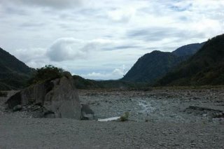
The car park leading to the galcier is featured in the Glenorchy thread. Past this point the track is gentle amble up a steep sided glacial vally, getting colder by the minute. We started in shorts and t shirts, but by the time we got there the fleece and windproof had been added. The terminus of the glacier is a dirty grey from the moraine or stones left as it retreats.


But the blue underneath is amazing, if you had to draw cold it wouldn't be white but this colour.

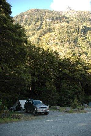
We stopped the night at the Rainforest Retreat. It was a beautiful setting set amid the lush bush of the west coast. It receives 7m of rain a year so qualifies as a rain forest I guess. The calling of the birds we don't know the names of was both magical and hypnotic. Its a shame therefore that the site itself was a real disapointment. The infrastructure and pitch sites were literally created by felling and blading the forest, then dozing many hundreds of cubic metres of river gravels to form roads. Cheap and effective for campers, a nightmare for putting tent pegs into! And the mozzies, don't talk to me about the mozzies!

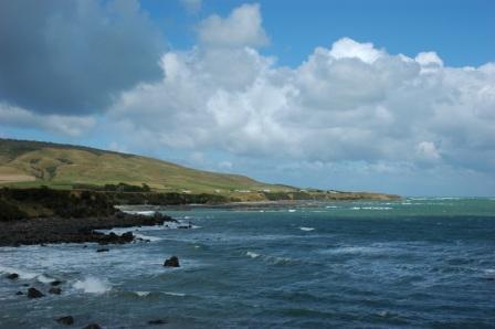
A few k's up the road, and another day another glacier. Franz Josef Glacier was named after the Emperor of the Austro-Hungarian Empire by explorer Julius von Haast. There are many glaciers in the Southern Alps, but Franz Josef Glacier and Fox Glacier are the only two that almost reach the coast. The terminal face of the glacier is currently only 19 kilometres from the sea.

It is a 40 minute walk from the car park to the terminal face of the Franz Josef glacier. The track follows a rocky path over riverbed.


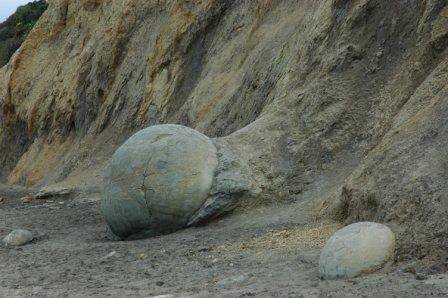
I overhead the guide of an adjacent group describe the geology as schist. I thought it was alright. Sentinel Rock (not pictured but a bigger version of below) emerged from beneath the glacier in 1865 and is an example of how the great bed of ice ground the hard schist bedrock into distinctive rounded rocks. Since 1909 the glacier has retreated over 3km and plants have progressively colonised where a veneer of rubble has been dumped over bedrock.

West Coast

Chris commented on an earlier post that driving up the West Coast was like driving through Kew Gardens (only with the sea on your left hand side!) - this is the view at just one of the very scenic rest stops.

Macetown

Macetown was an off road route that I'd particularly wanted to do. After winning tickets for the gondola at Queenstown we were further south than we'd planned to be, so I suggested camping at Macetown. Located 15km from Arrowtow, itself a living memory of a substantial gold town of the early 1860s goldrush days, Macetown is now a ghost town, which was always remote and its climate harsh, but it only closed down when the mines eventually failed. We dined at an attractive restaurant overlooking the Arrow River. Meal over, we started the arduous route through to Macetown along the route of the Arrow River. After half a dozen river crossings and the track inclining up a steep ravine the girls cried stop. So we turned around and made our way back to Arrowtown and the campsite there. Alex and I left the girls to set up camp and we went off to play.

We didn't have long, it was after 8.30 pm already. We soon retraced our journey across the river many times.....

...and climbed up the sides of the valley...

....down another track as it wound deeper and deeper into the hilly countryside.

You don't get views like these from a rental.

10 km into the route it was after 9 pm and still there remained another 5 km to the town. It was getting dark though, and I didn't want to do anything too risky obviously with Alex with me. We turned around and headed back the way we came. A solitary faded wooden cross next to particularly steep section of track a reminder why the trails should be respected.

It was after 10 pm and fully dark when the boys returned to camp. Bedtime for Alex and a glass of wine for me.

Queenstown

Vanessa was gobsmacked she'd won the draw at Milford Sound. Ironic really as she hates gondolas/cable cars! Alex did the wobble it a bit routine until resoundedly told off. The gondola ride is an incredibly steep ascent above Queenstown.

At the top there is a hotel/visitors centre place. Great view.


There's also a luge track, basically go-carts. Another cable ride to the top of the luge course.

We all (except V) had a go with our own cart, but it was a bit steep and Alex had a few thumps into the side and I was half controlling him by colliding into him. We went tandem from then on. Shannon, the speed demon, then too the fast course, leaving Alex and I to do the standard. We made good progress though and overtook quite a few people over the next 3 goes.


Milford Sound

We arrive in Te Anau hoping to be able to go on a cruise to the glow worm caves but unfortunatley they are all booked up! Needless to say this results in two very bad tempered children. The intention had been to stay here the night and drive out to Milford Sound early tomorrow morning to catch the fiord cruise but, as we are now at a loose end, we decide to drive out there today and camp there instead. So after a quick lunch, the children bid farewell to the huge takehe bird and we're off.


Fiordland is one of the most dramatic and beautiful parts of New Zealand. It is renowned as its sightseeing and walking capital. The drive from Te Anau to milford sound is about 2 hours long but it is through the most stunning scenery that it seems to take no time at all (for the grown-ups that is!!!). Human activity has been limited in Fiordland. European settlement was hampered in this area by the steepness of the terrain, isolation and the wettest climate in New Zealand. Early Māori people hunted birds here and caught fish from the sea and gathered pounamu (New Zealand jade) from the rivers. Later, sealers and whalers took shelter in the fiords and built small settlements in a number of locations.

We arrive at our next camp site and pitch tent on a gravel (yes really!) pitch. and have a qick drive out to see the famous Milford Sound before tea. Camping here is a very social activity - cooking tea takes place in a very well appointed (if small) kitchen along with visitors from Germany, Sweden, America and Ireland. The pitch was surprisingly comfortable but unfortuantely Milford Sound appears to have a very high sandfly population and we are all covered in festering bites by the next morning. We head of back to Milford Sound to start our boat trip.

Milford is by far the best known of all of the fiords and the only one that can be accessed by road. It is approximately 16km from the head of the fiord to the open sea. In Maori legend, the fiords were created not by rivers of ice, but by Tu Te Raki Whanoa, a godly figure who came wielding a magical adze and uttering incantations. When is was originally discovered by English sailors, it was named Milford Haven, after the Captains home town.

Camp Ford

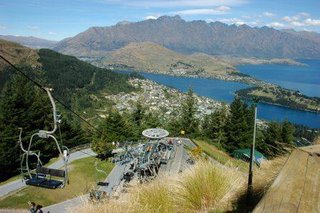
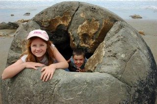
Yes - it really is a dolphin!!!!!!!!!!!

The boat took us right under this waterfall and it was b****Y cold! but a fantastic experience. Good job they provided free tea and coffee though - my hands were blue!

Mitre Peak, shown in this picture, is so named because of it's similarity to the bishops headgear of the same name. Is is, supposedly, the most photographed mountain in New Zealand. I can see why!!!!

The trip lasted 2 hours and for me it has been the most awe inspiring of our New Zealand trips to date - to say the scenery is stunning here does simply not do it justice. Fantastic!!!

Monkey Island

No player of the one of our old favourite PC games would pass a signpost to Monkey island without further investigation. It proved to be an island only at high tide but we didn't let that get us down.

And here is one of the more rare inhabitants..

And to prove that there is a lot of weather here, the above picture was taken to the south of Monkey Island only seconds before the picture below was taken to the north. Guess which way we were heading!


Invercargill and Bluff

Invercargill is New Zealand's southernmost city, it's early prosperity resulted in the construction of many fine buildings (none of which I have photos of!) which make it a pleasure to drive through (that and the distinct lack of traffic!!!). As we drive towards our campsite, we see dozens and dozens of classic cars. The camp site owner informs us that we are lucky to get a pitch as there is a big car show the following day.

We pitch tent and decide to head out to Bluff, the most southery point of the South Island. It's a very mixed drive as there is only one road out to Bluff and one muinute you're driving through beautiful scenery, the next minute through a grubby industrial area.

Bluff is unique in the fact that it is the oldest European settled town in New Zealand. It is dominted by the port full of fishing boats. It is one of the most famous suppliers of oysters in the southern hemisphere. We drive out to Stirling Point which is to New Zealand what Landsend is to Great Britain. There is a high lookout tower where you can see views out to Stewart Island. It was incredibly windy as we made our way up there. In fact, it was so windy that Alex could barely stand and decided to go and sit in the car. The views from the top were fantastic.

The island with the lighthouse on is Dog Island.

Cannibal Bay

Rumbling tummies demanded an unscheduled stop and as Cannibal Bay was looming, and had a great name, we decided to stop there. What a gorgeous place! Home to protected sealions (although they weren't in residence when we visited) and a multitude of seabirds it was reached down a very windy road - well worth the bumpy drive.
Maybe it's me being fanciful but this rock looked like an old cannibals face to me!

Sad News

Sadly we received a phone call late on Tuesday from our friend Sally to say that her father had died and they were flying back to England on Thursday. We didn't have a chance to see them before they left but they are in our thoughts.

Dunedin

Arrived in Dunedin after a pretty long drive, all a bit grumpy and ready for some tea. The drive through the city did nothing to inspire us - party due to the busyness of traffic. We eventually found the camp site, paid our dues and went to find our pitch only to find that the site was on a hill and our pitch was on a little terrace at the top - as far from the facilities as you can get. Oh well, tent pitched - off to check out the famous Octogon, the plaza at the centre of Dunedin.

Dunedin was settled in 1848 by Scottish immigrants and has become know as the "Edinburgh of the South". It certainly has some lovely buildings (and a HUGE Cadburys factory!! - smells great) but the Octogon pedestrian area was nothing special and all the eating places were pub based and expensive so back in the car in the hunt for a chip shop.

The following morning we wake to the sound of very, very heavy rain. The propsect of travelling to our next destination with wet, cold children is not a happy one so Chris and the children are sent off to the heated swimming pool for a combined swim/wash and I take down the tent and pack the car. By the time we are ready to go, the kids are chirpy as hell and I'm wet through, freezing, have a big gash on my hand from the tent pole and generally in pretty foul mood - the rain continues!!!!!

One of the places we had wanted to see was the Albatross Sanctuary which is based at the far end of the Otago Peninsular so we head off in that direction in the hope of finding breakfast on the way.


We arrive at the peninsular tip and it is so cold that we have to pile on all available clothes in order not to freeze to death (and it's still raining). There is a short walk along the cliff tops where we are able to see some seals and the King Shag colony but in order to wlk around the cliff to see the Albatross colony you have to pay the princly sum of $80 - I think not!!! Instead we spend some time going round the (free) exhibition.

We head off back along the peninsular, stopping to take a photo of Dunedin in the distance (yes, it's still raining!).......

... and arrive at the only castle in New Zealand.

Larnach castle was built 1871 by William Larnach, merchant baron and politician, for his beloved first wife Eliza. 200 workmen spent three years building the castle shell and master European craftsmen spent a furthur 12 years embellishing the interior. It is privately owned and has been restored to its former glory by the current owners. It is a beautiful building but is more like a manor house than a castle.

Back into the car for the next leg of the journey and, hooray, it has finally stopped raining.

Moeraki Boulders

Given that several of the places we wanted to visit this week are on National Park land, we sadly decided that Diesel would have to holiday on his own at the local kennels. Once he was safely ensconsed, we headed south. For once, traffic was pretty heavy on State Hghway 1, and roadworks plentiful so it took us longer than expected to reach our first stop, the Moeraki Boulders (by which time the phrase "when's it lunchtime" had become banned due to overuse).

The Moeraki Boulders are huge spherical stones that are scattered over the sandy beaches, but they are not like ordinary round boulders that have been shaped by rivers and pounding seas. These boulders are classed as septarian concretions, and were formed in ancient sea floor sediments. They were created by a process similar to the formation of oyster pearls, where layers of material cover a central nucleus or core. For the oyster, this core is an irritating grain of sand. For the boulders, it was a fossil shell, bone fragment, or piece of wood. Lime minerals in the sea accumulated on the core over time, and the concretion grew into perfectly spherical shapes up to three metres in diameter.

Chris' commented that it looked like the cliffs were sh*****g the boulders - charming!!! See what you think..


And, for the first time ever, photos of the birth of rock monsters.....


and onewards to Dunedin...

Tuesday, January 17, 2006

Gone Camping.....

We've decided that we might as well check out the rest of what New Zealand has to offer as there are no jobs forthcoming so we're off camping - updates to follow next week.

Monday, January 16, 2006

Glenorchy Rally 2006 - Day 2

Part 2, if you haven't read Part 1 yet scroll down ;)

The morning was damp and miserable. My compadres were all heading back up the way I'd been the day before. They thought the West Coast would be a wet ride. Not knowing if I'd get the chance to ride it again I decided to go for it.


The ride back to Queenstown was through the pouring rain. I stopped for fuel and had to defrost my hands under the drier before I could drink my coffee, it was like a winters ride. Was I letting myself in for worse on the west coast? This view is towards Queenstown from the start of the Crown Range road towards Wanaka.


You've seen the shoe fence, now the bra fence outside Cardrona. The Crown Range road was superb, there were flourescent road markers along the sides of the road for when it snows.


Lake Wanaka.


SH6 to the west coast first skirts the western shore of Lake Hawea (shown), bears around Isthmus Peak ad then skirts the north eastern shore of Lake Wanaka.


Exiting Lake Wanaka SH6 then enters the Mount Aspiring National Park and continues through densely clad, between almost vertical mountainous passes. It was drizzly and the road surface was wet, but boy was it grippy!


SH6 emerges at Haast. This is a view up the Haast River, Mosquito Hill to the left and Mt Browne on the right.


Despite the opinions on the weather I couldn't have got better. It had been raining heavily but the sun had burnt most of it off, in places steam billowed up from the road surface as I tore along it. The scale of the greenery all along the west coast needs to be seen to be believed, I'd read about it but couldn't picture it from the words. Imagine fast sweeping bends, tight twisty mountain passes and fast valley straights surrounded by Kew Gardens ... for about 200 miles, with only 20 or so other vehicles. Biking nirvana!


View southwest from Knights Point Lookout.


View northeast from Knights Point Lookout, the road sweeping inland towards Lake Moeraki.


I think this was Bruce Bay.


One of many rivers crossings.


A quick diversion up to the Fox Glacier.


SH6 sweeps through National Park after NP, this is in the Westland National Park.


Pie and chips in Whataroa for lunch.

I think this is the Waitaha River.

No pics crossing Arthurs Pass, this is the Waimakiri River.

Castle Hill.

The final descent down to the Canterbury Plain.

Back home, I'd covered 916.2 miles in 2 days. I was sore, I was tired but what a fantastic weekend, just what I needed. That's what the roads in New Zealand are like!

Or instead of the thousand words I could have posted just one picture, before and after!